Intelligent Systems for Industrial Assets.
We bridge the gap between complex spatial data and actionable management. From AI-based asset identification to enterprise-grade management systems, we design the software that powers your infrastructure lifecycle.
Managing Infrastructure Through Intelligence
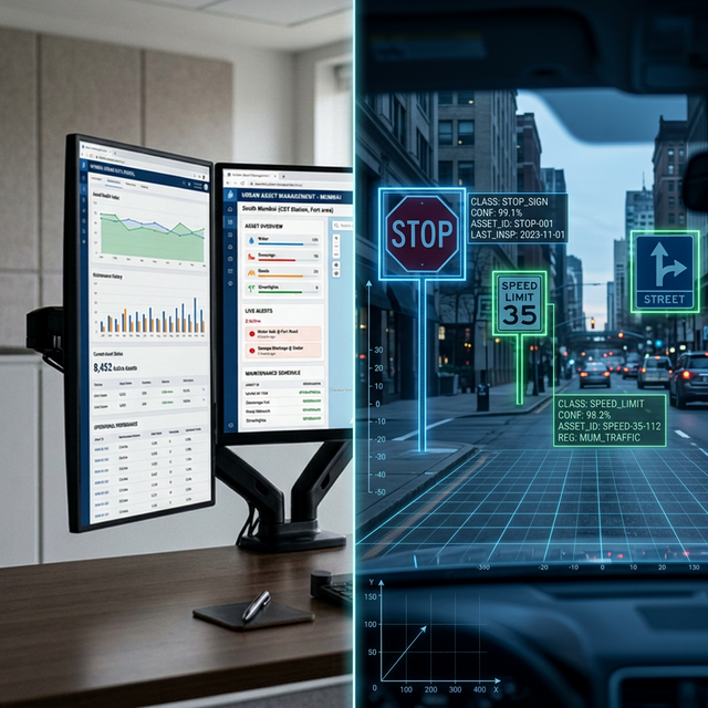
Modern infrastructure management isn't just about collecting data; it's about turning that data into a live, queryable registry. Our AI and software practice specializes in identifying assets automatically from reality capture data—allowing us to populate large-scale Asset Management Systems (AMS) in a fraction of the time required by traditional field methods.
Beyond inventory, we build Design Support Systems (DSS) that help your engineering teams make better decisions. Whether you are managing state-wide highway networks or municipal water schemes, our custom-built platforms give you 100% data sovereignty and total control over your asset lifecycle without recurring license lock-ins.
"Replacing manual data entry with trained computer vision models ensures asset registries are not just faster to build, but fundamentally more objective and accurate."
— Lead ML Engineer, Geopage Consultants|Supporting MoRTH Asset Digitization Mandates
AI-Ready
Asset Identification
Live
Management Portals
Zero
License Lock-in
AI Asset Identification
Automated extraction of infrastructure assets from LiDAR and high-res imagery. We use custom CV models to identify and geo-tag signs, poles, and utility assets at scale.
Asset Management Systems (AMS)
Enterprise-grade platforms built on open spatial standards. We deliver custom dashboards to track maintenance, age profiles, and condition history across your entire asset portfolio.
Design Support Systems (DSS)
Custom computational tools that aid engineering decision-making. From automated pavement scoring to hydrological risk assessment, we turn complex data into design clarity.
Integrated Management Platforms
End-to-end systems that link reality capture data directly to management workflows. We bridge the gap from a 3D scan to a queryable, actionable management record.
Technical FAQ
Ready to make your infrastructure intelligent?
Send us your project brief. We'll get back to you within 24 hours.