Preserving Stone in the Digital Age: LiDAR Documentation of Heritage Temples
How 3D laser scanning creates condition records for heritage structures that no photograph can match.
A heritage temple isn't just a building. It's an engineering record that has somehow survived for centuries. When the stone starts to fail, the absolute first step is documenting exactly what is there, in enough detail to plan a repair or, worst case, a reconstruction.
Why photography isn't enough
Photography is the default way people document heritage sites. It's fast, it's cheap, and the pictures look great in a report. But a photograph has a fatal flaw: it only captures surfaces, not geometry.
If you're a structural engineer trying to save a leaning wall, a photograph doesn't help much. You need to know exactly how thick the wall is, how far the arch spans, and how much the structure has settled. You also need to map the exact coordinates of every crack and patch of biological growth. You simply cannot pull that data out of a flat photograph. LiDAR scanning gives you all of it.
Scanning a complex site
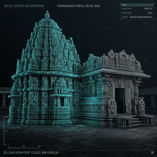
We recently documented three heritage temple complexes—about 100,000 square feet of ornate stone. You can't just walk in with a measuring tape. We had very specific constraints:
- We couldn't physically touch the stone surfaces during the survey.
- We needed the scanning resolution high enough to capture fine sculptural details, which meant placing the scanner every 3 to 5 meters along the main facades.
- We used photogrammetry to fill the gaps. Where the LiDAR point cloud wasn't dense enough for intricate carvings, we brought in close-range camera capture to get the texture right.
- We had to build temporary scaffolding to get the scanner up to roof level and capture the angles you can't see from the ground.
We used a FARO S350 scanner for the main structure because it's fast and reaches far. For the cramped shrine interiors, we switched to a smaller FARO X330 to make sure we didn't leave any blind spots.
What you actually get from the data
When you stitch all those scans together, you get a forensic, millimeter-accurate 3D snapshot of the temple frozen in time. For the conservation team, this changes everything:
Finding the cracks: You can spot individual cracks on the stone, measure exactly how wide and long they are, and attach those measurements to 3D coordinates.
Watching it move: By comparing the scanned geometry against a true vertical baseline, we can measure exactly how much a gopuram or a column is leaning. You can't eyeball a 2-degree lean on a 50-foot tower, but the point cloud sees it immediately.
A baseline for the future: Every arch, lintel, and carved panel is recorded. Ten years from now, another survey can compare against our baseline to see exactly how much the stone has eroded.
Dealing with the paperwork
If you touch a protected monument in India, you deal with the Archaeological Survey of India (ASI) or State Archaeology departments. They demand very specific documentation. Our scanning process generates exactly what they need: raw point clouds, orthophotos, and highly accurate CAD plans, sections, and elevations cut directly from the 3D model. We format everything specifically for conservation grant applications.
The backup plan
Scanning a temple isn't just about planning tomorrow's repair. It's about securing the asset against the unthinkable. If an earthquake, flood, or fire destroys the structure, the LiDAR model provides the exact geometry needed to rebuild it. People have successfully reconstructed ruined monuments using pre-disaster LiDAR data—something that would be impossible with just a file folder full of old photos.
Working on a heritage conservation project? Get in Touch →